DETER system shows reducing deforestation in the Brazilian Amazon
fevereiro, 25 2014
Alerts of deforestation in the Brazilian Amazon from August 2013 to January 2014 dropped by 19% compared to the same period last year.
Alerts of deforestation in the Brazilian Amazon from August 2013 to January 2014 dropped by 19% compared to the same period last year. The data, released on Friday (21) by the Brazilian Ministry of Environment, are from the Real Time Deforestation Detection System (DETER), of the National Institute for Space Research (INPE). It is a satellite-based system and has intention to guide the monitoring field, demonstrating the trend of deforestation rates over a period.During this period, DETER shows that 1,162.50 km² have been cleared – something like 116,200 soccer fields – while in the same period last year were identified alerts in an area of 1,427,990 km ². According to the Ministry, the system identifies deforested areas exceeding 25 hectares (61.8 acres) from satellite images. DETER works like a support for monitoring. "The data serve as a landscape management of the Amazon region. The change of the landscape may occur because of issues like deforestation or even burning," as says the press release of the Ministry.
During the press conference for data dissemination, the Minister of the Environment Izabella Teixeira said that there is a possibility of the alerts issued by DETER be caused by legal actions of change of the landscape along the lines of new Brazilian Forest Code. According to the data, 32% of the alerts occurred in other areas of federal jurisdiction as protected areas, indigenous lands and settlements.
According to Marco Lentini, coordinator of WWF-Brazil's Amazon Program, the decrease estimated by DETER has to be observed with caution. "These data need to be validated, although early reports are good. However, if we use Prodes as a basis – which is the official rate of deforestation of the Brazilian government – we had more bad news than good on the last statement. In all scenarios, the Amazon deforestation remains high, which suggests that we urgently need to advance in structural actions such as large-scale implementation of rural environmental cadaster, forest restoration within private properties, and enforcement of the environmental law and actions of planning of land use, especially in the production of commodities".
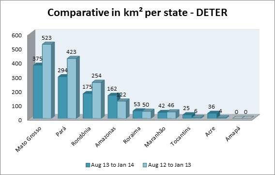
Data: Brazilian Ministry of Environment
DETER data shows a reduction of alerts on States that traditionally have the highest rates of deforestation, such as Mato Grosso, Rondônia and Pará, while Acre and Tocantins had an increase comparing to the latest indexes, but still remaining with the second and third lowest number of alerts of the region, respectively.

Vista aérea da floresta amazônica no Acre.
© WWF-Brasil/Bruno Taitson

Vista aérea da floresta amazônica no Acre.
© WWF-Brasil/Bruno Taitson